|
| Home | # 1 | # 2 | # 3 | # 4 | # 5 |# 6| # 5 |
|||||||||||||||||
|
5-7 May 03 Swansboro NC to Norfolk, VA Sunday evening, the 4th of May, we pulled into Casper's Marina in Swansboro NC right around closing time. Chris and T topped off the internal diesel tank, filled the jugs and T went for a record short time to change the oil. (He did it in 22 minutes). I paid the slip fee and fuel bill, sent email (log # 4), got the combination for the head and showers, and got recommendations for eating out. We closed up the boat and went to one of the four restaurants in town. At dinner, we swapped stories about getting lost (mine were mostly flying stories) and running low on fuel. 5 May
We got secured in the slip at the marina and then I headed off to the dockmaster's office to take care of getting signed in. The guys adjusted the idle speed, changed the Racor fuel filter, checked the raw water strainer and did other chores before we walked across the street to see the town. Lunch was a burger at the pool hall and then we went next door to the pottery shop to talk to Chris' friend, Patty then back to the pool hall to meet Patty's husband, Tipper. They asked us to dinner which we accepted and then we went off in search of warmer clothes. Our Florida togs were a little light for the cool weather we encountered on the NC coast. Our search proved more difficult than we expected as the shop keepers had all changed their inventory to summer clothes a couple of weeks ago. We also picked up provisions -- bread, milk, bug spray, ice and more fuel. We picked up a couple of bottles of wine and headed out to socialize. Tipper Davis is a carpenter. He and Patty lived on a 65 foot schooner (that Tipper built) in the same marina where Chris lived in Solomans Island, MD a few years ago. Tipper does historic restorations, like George Washington's Grist Mill (wood gears, etc.). They also chartered their boat in the Caribbean and have done lots of sailing. They found a nice house in Beaufort, moved in and Tipper does his work in a great wood shop he has set up in his back yard. Patty is totally consumed with her pottery import business and is doing quite well with that. Beside two fulltime occupations, they are also trying to remodel their house. The current project seems to be the front porch and a new kitchen is next. We had a great evening discussing boats, sailing, flying and classic Airstream trailers. Since we were planning an early start the next morning, we headed back to the boat a little after 10 PM. There we listened to the weather on the VHF radio and decided to get an early start and just go as far as we could. The guys had already identified rivers and creeks which would be good to anchor in if the weather turned bad. 6 May We were up at 5:30 AM and ready to leave the slip at 5:55. We called the first bridge on the VHF radio to see about the opening schedule. We were told the bridge would open at 6 AM (we would never make it), 6:30 and 7 AM. We decided to leave and make the 6:30 AM opening. After orbiting for 25 minutes and sipping coffee, we slipped through the opened bridge and headed out into the inlet between Beaufort and Moorehead City. I was at the helm, T was navigating and Chris was just enjoying the view. It was dawn and a nice sunrise. We were spotting makers by their lights, their shape and their color. As with any intersection of several navigational routes, there were a lot of markers to sort out as we moved from one channel to another. The route between Beaufort and the ICW seem straight forward and T and Chris were chuckling about one of their friends that had run aground in this area on a previous trip. Right in the middle of their story, we hit bottom ourselves and we were stuck. Chris laughed at our situation and then both guys sprang into action. Moving to one side of the boat they both leaned over the side as much as they could and I reversed the engine at as high a speed as I could. Their weight heeled the boat, shortening the length of keel in the water and we slide off the bottom and were free again. As Chris got focused on our route and suggested we backtrack and follow the deep water route we just passed (it was not marked as a channel on the chart) rather than try to navigate the very narrow channel that we were headed toward (turn northwest just before Fl G 15ft 4M "36"amd follow the deep water).
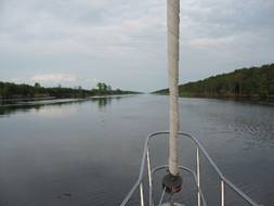
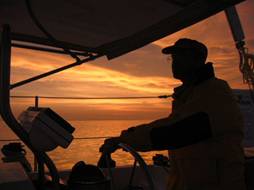
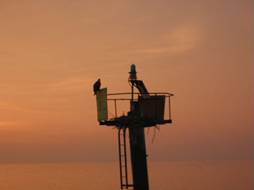
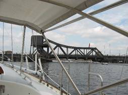
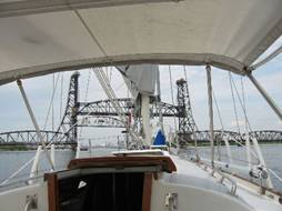
I took a turn at the helm about sunset and then again about 10 PM. The weather held all day and the water was very smooth. We decided to keep going. The nighttime navigation task in this part of the ICW is simpler than in the harbor and inlets where we have had problems distinguishing one marker light from all the rest. Here there are lots of marker lights, but as you pass each one on your path, the next ones generally appear in the distance. It seems like we are the only vessel moving on the waterway. We have passed many anchored just off the channel in places like the south entrance of Alligator River (mile marker 101). They are the high white lights we see just off our beam (the side). Late into the night, the fighters from Cherry Point are still flying -- very low right over our route (looked like practice night low level missions). In the middle of the Alligator River we needed to pass through a swing bridge. I was at the helm while we were waiting for the bridge to open. A swing bridge pivots horizontally on its center point. We were orbiting while waiting for the bridge to rotate and the current was pushing us into the bridge. Just as the bridge started to swing, I pulled the power to idle to slow my approach and the engine stalled. Suddenly, we were drifting swiftly toward the abutment with no control. Thankfully, the engine restarted immediately and I was able to get realigned with the channel and pass through the bridge. 7 May We traveled the length of the Alligator River, crossed the Albemarle Sound and entered the North River. About 1 AM, Chris came up from the cabin where he was sleeping. I turned the helm over to him. I prepared the foredeck for anchoring later on by pre-positioning the necessary equipment. I figured when it happened, I would not be thinking as well coming up from a nap then I was now. I told Chris to call me when we decided to anchor and retired to my bunk. These guys are something else! Chris just kept going through the night. The water was smooth, no one else was out there, the weather was good, and we were making good time. T was sleeping in the cockpit and I was sleeping below so Chris just kept going!. At 4:30, the boat stopped abruptly. We had run aground! Within minutes, we were all up. And leaning over the side, rocking the boat, moving our weight to the bow and then the stern -- we tried everything to unstuck the keel from the bottom. Finally, we sent T for a ride as weight at the end of the boom and then moved it perpendicular to the boat. That tilted the boat enough for us to break free. We tried the approach to the channel again, but more slowly, and again we ran aground.. We sent T out on the boom again and we backed off the shoal. Chris was getting frustrated. He was following all the markers he saw and he couldn't find deep enough water. Then he spotted an unlighted marker indicating the shallow area we were confirming. Now he knew how to proceed and off we went. Chris finally went to bed and T and I navigated the boat through the North Carolina Cut between the North River and Coinjock Bay. We continued north up across Currituck Sound and up the North Landing River passing Pungo Ferry (a small community) and then into to the Albemarle and Chesapeake Canal. All these waterways and dug canals and hundreds more like them make up the ICW.
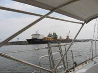
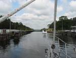
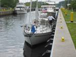
More swing bridges and more boats now that it is
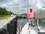
daylight. More slowing down to let them pass. We passed through a lock at
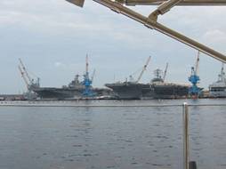
We will stop in Norfolk for fuel and then head out for Mobjack Bay in the Lower Chesapeake (Northern Neck in VA). Now weather becomes a big factor. |
|||||||||||||||||