|
| Home | # 1 | # 2 | # 3 | # 4 | # 5 |# 6| # 4 |
|||||||||||||||||||||||||
|
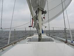
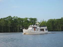
2-3 May 03 Charleston to The decision After a late night (Chris and T exploring historic Charleston and me plugged into a phone jack outside a closed marina office trying to send email), we woke up about 7 AM and went to breakfast at a nearby restaurant. The waitress there had served us the day before and started kidding T by calling him "Captain Gravy" because he kept ordering more gravy for his lunch the day before. The kidding continued both ways with us suggesting she join our crew. As we stuffed ourselves, we discussed options for the next leg. The big question is: do we go outside into the ocean or do we stay inside and go up the Intracoastal Waterway (ICW)? Outside in the ocean is much faster if winds and sea are favorable because we can travel a straight line from one point to another. Inside via the ICW takes longer because the route winds through a system of rivers, sounds, bays and canals. We also have to watch our depth to ensure we don't run aground and we have to ask bridges to open if they are lower than 46 feet. The bridges are less frequent in this part of the ICW than in Florida so that is less of an issue. Boat traffic is more of an issue since we need to slow and let all bigger and faster boats going the same way pass us (that means most boats). So, the plus for the ICW option is that it is a very comfortable ride with interesting scenery, but it is a lot longer trip. Going outside is much faster, but wind and sea need to be right. There are tradeoffs to consider with either option. When we left the restaurant, we were staying inside. By the time we were ready to shove off, we were going outside. The deciding factors were the high pressure weather system over the area (a stable period of good weather) and the fact that there were three opportunities along the planned route to duck inside and connect with the ICW -- Georgetown SC, Frying Pan Shoals, and Cape Fear River NC.
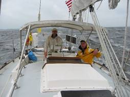
We finally entered the inlet, passed some ruined jetties (that's how they were marked on the charts so we think they were jetties that had settled in the sand and were not breaking the waves as designed) and found some flatter water inside. By the time we got inside the inlet, we were all soaked from the spray, it was getting dark and we were all tired. There was a thunderstorm ahead which concerned T and since we had made good progress, we all decided to drop the hook (anchor), cook some dinner, and talk about options. We anchored just south of where the ICW intersects the body of water that flows into the ocean, just around the bend from Georgetown. We heated up some beef vegetable soup and decided to spend the night on the hook. An early start up the ICW seemed more prudent than continuing at night. In addition, since T hadn't spent much time on the ICW, he needed to learn the routine which is easier done in the daylight. We were all asleep by 9:30 PM. I got up a couple of times to check the anchor. It seemed to be holding. The current was strong and the wind was opposite the current so we experienced some twisting around the anchor, but it was not dragging. We set the GPS anchor alarm before we slept (an alarm that will sound if your position changes by a certain amount), but a half mile deviation seemed like a lot of error to me. My alarm went off at 5:30 AM. I dressed and woke up the boys. We pulled up the anchor and departed the anchorage by 6 AM. I has been six years since I last dropped the anchor so it took me a couple of tries to get the windless (raises the anchor) and the wash down pump set up correctly. (Circuit breakers and seacocks need to be set correctly). I was delighted. The anchor came up easily and I hosed off the mud just before it went into the chain locker.
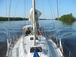
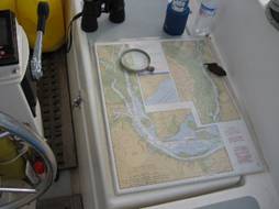
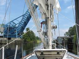
. At night things become more complicated. Some, but not all of the markers are lighted with red and green flashing lights. One marker is distinguished from another by the flash interval (2.5 sec., 4 sec., 6 sec., quick, etc.). The unlighted markers (day markers) are still out there, but must be located with a handheld spotlight. Their numbers are reflective so they are easily seen if you shoot the light in the right direction. The feel is different at night. You are traveling at the same speed toward a known marker (flashing light in the distance and all these unlighted markers, pilings and other obstacles are passing by in the dark. When you enter a harbor or intersection of several waterways, at night things get really interesting because you have to distinguish which of the lights you are seeing (including cars and signs on the shore) are the lights you want. For example, picking out your flashing 4 second red marker is difficult if it is located in front of several cars with red taillights stopped at a traffic light. Our easy day made us think it might be a good idea to travel throughout the night. We have three of us and one could always be sleeping and we could rotate watches like we do offshore. I was taking a turn at the helm after dinner, dressed in my tropical weight foul weather gear. I thought I would continue until about 9 PM and then get a nap before I came back for another shift. Chris was off and looking over the charts because we were approaching Cape Fear River inlet and he has had several bad experiences in that locale. T was helping me navigate by watching the chart and identifying the next marker and updating the location of the pelican. T suggested Chris get some sleep so he retired. That left me steering the boat and T navigating with the chart. No problem... until we entered Cape Fear river. When the wind kicked up to about 25 knots and we turned up the river. The wind was blowing down a long fetch against the current which made the water very turbulent. In fact, the waves were about 6-8 feet and about the length of the boat which made the boat "hobby horse". The bow was rising high into the air and then slamming onto the trough of the next wave. We hit so hard we were stopped or set back several times. For 5 knots to zero, instantaneously. Chris was trying to sleep below, but not having much luck. After about 30 minutes of pounding, our heading changed slightly and it was rough rather than pounding. As we headed up the Cape Fear River, things became very complicated. Several navigational routes intersect in that area. Also there are several vessels at anchor with multiple lights. Also there are several tugs and barges moving around each with their own lights. Needless to say, T had his hands full checking the charts (with a red flashlight so we keep our night vision), finding the correct next marker, pointing it out to me so I can steer toward it, and looking ahead on the chart to plan for what's coming. I had my hands full steering with waves, winds and current. If things weren't bad enough, about the time we entered Cape Fear River, we became surrounded by lightning storms. They seemed to be in the distance and were only a distraction when we happened to see a flash in the distance (doesn't help the night vision). Anyway, lightening in the distance was not as much of a problem as the wind, current, waves, periodic rain, and confusing network of navigational routes and multitude of lights and markers. The new plan became to get through the river and back into the ICW and anchor for the night in a protected spot. Chris was up and trying help T identify a spot to anchor where there might be some protection, the water would be deep enough, and we wouldn't interfere with other vessels navigating the ICW. That's when Chris noticed we were not on the correct channel. We had taken the wrong turn at the last 'Y' and gotten off the route to the ICW. There was some discussion about a short cut to get back to the correct channel and then Chris discovered a depth of 3 feet (my boat requires 5 feet minimum). That plan had to be jettisoned. And it looked like we had to go back to the wrong turn. Oh, by the way, the lightning in the distance… It was all over us. Striking the ground and water all around. This is not comfortable when you are a big lightening rod floating on the water. And seeing things in the dark is much harder (except for that brief second when everything gets lit up. Remember there is no running, no escape when you can only make 5 knots). You just have to make do with what you have and slowly improve your situation. Just when I though things couldn't get any worse, I looked ahead and noticed a wall of rain starting to obscure the marker lights we were headed toward. We could barely make our any lights and were at risk of being blown off the ICW (which in only 100 Feet wide) into shallow water, obstacles or whatever. T sprang into action and directed me to hold at the lights we had in sight. I was delighted. The thought of leaving our only know location and driving off into a blinding rain and hoping to stay in a narrow channel, was the last thing I wanted to do. I shouted back to T that I didn't think I could hold, but I could orbit and we had plenty of depth. T said OK and that's what I did. My job was to provide some stability and hold our position and stay out of the way otherwise. That's a role I was happy to play. I focused on orbiting the navigation light in the blinding rain, high wind, strong current and lightning strikes everywhere. Just when I thought things couldn't get worse, it started to hail -- marble size hail. Luckily, I had professionals onboard. Chris and T were busy planning our escape. They found a reasonable anchorage, not too far from our location and when the intense part of the storm passed, we headed there. Pulled off the channel and dropped the anchor. I went below to get out of my we clothes. My tropical weight foul weather gear kept me from getting soaked, but I was still wet and I only had boat shoes on and they were soaked. Remember, I was only going to be at the helm for another thirty minutes, then take a nap. Well, I guess I should have been prepared for the worst. Once we were convinced the anchor was holding, we closed up the boat and went to sleep. The storms moved off. On Sunday, we were up at 5:30 Am and headed back to the channel we needed and reentered the ICW. When the ICW runs through other waterways things get really complicated. We all decided next time we would all do it in the daytime. We all identified lessons learned. T documented his in the ship's log: visibility is everything, do Cape Fear inlet only in daylight, go with your gut feeling (he wanted to stop earlier), the value of teamwork (he and Chris). I was just thankful I had experienced people on board and learned a lot about handling the boat in heavy weather, the importance (for me) of their confidence that I could contribute (orbiting the navigation light) even when things were at their worst and the importance of just holding position and making a plan when things are crazy (a good strategy for another time).
|
|||||||||||||||||||||||||